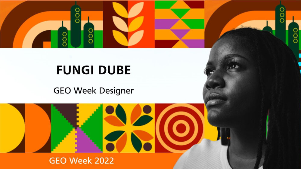
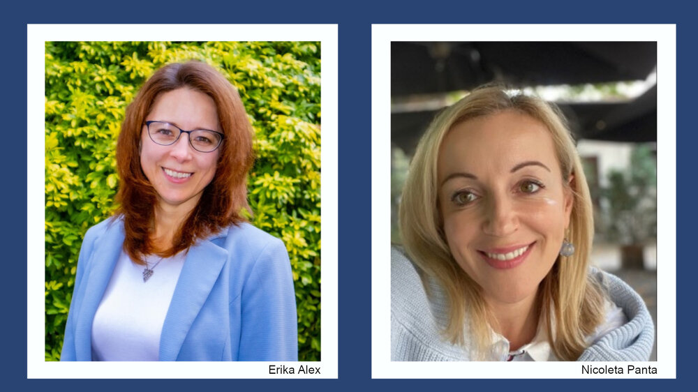
Global Land Outlook</a> second edition (GLO2), published recently by the United Nations Convention to Combat Desertification (UNCCD), shows that each dollar invested in restoring degraded land returns between $US7 and $US30 in benefit. The GEO LDN Flagship provides trusted tools and information to monitor land condition across all scales and landscapes, so countries can improve their land management. The Flagship supports the UN Sustainable Development Goal (SDG) Target 15.3 on land degradation, which targets the restoration of nearly one billion hectares of land by 2030. Achieving this target requires a holistic approach, ensuring that nature is protected, agricultural lands are sustainably used, and degraded land is ecologically restored."}},{"id":"6802843449d2f","type":"paragraph","data":{"text":"GEO Secretariat Director, Yana Gevorgyan said: “Globally coordinated Earth observations can provide the trusted information to protect nature, restore degraded land and manage agricultural land sustainably. Supported by a EUR 6.2 million contribution from the Government of Germany, we are launching the GEO LDN Flagship in response to a critical need for better information, better tools, and skilled practitioners to accelerate achievement of all 17 Sustainable Development Goals.”"}},{"id":"6802843449d30","type":"paragraph","data":{"text":"GLO2 projects degradation of 16 million square km – an area the size of South America – through to 2050 if current trends continue. LDN encourages the optimization of all land uses across the landscape, so that the competing demands for land resources including food, feed, fibre, clean water, clean energy, the carbon sequestration, and the protection of nature, can all be achieved."}},{"id":"6802843449d31","type":"paragraph","data":{"text":"Dr. Barron Joseph Orr, Lead Scientist of the UNCCD, said: “Addressing the problem through the right mix of conservation, sustainable use and restoration measures makes economic sense. But it is a daunting challenge to provide suitable data and information across the extraordinary variety of landscapes and land uses across the globe.”"}},{"id":"6802843449d32","type":"paragraph","data":{"text":"The GEO LDN Flagship will be hosted by the Deutsche Gesellschaft für Internationale Zusammenarbeit (GIZ) GmbH, on behalf of the German Government. Ms. Antje Hecheltjen, Coordinator of the Flagship Secretariat explained: “Delivering for, and co-developing with governments and local communities drives the work programme of the GEO LDN Flagship. Our key challenge is to help countries to capitalise on advances in EO by making tools and datasets open source and interoperable, supporting their use for LDN, and developing a curriculum of study to build expertise and capacity in LDN around the world.”"}},{"id":"6802843449d33","type":"paragraph","data":{"text":"The announcement was made during GEO’s 18th Plenary, currently being held in Accra, Ghana."}}],"version":"2.29.1"},"created_at":"2023-11-20T19:47:02.000000Z","updated_at":"2023-11-20T19:47:02.000000Z","is_hidden":false,"image_caption":null,"tags":[]},{"id":23,"title":"Meet Fungi Dube, GEO Week designer","slug":"meet-fungi-dube-geo-week-designer","image":"/storage/news/2022/20221029_fungi_designer.jpg","published_at":"2022-10-29 18:49:56","content":{"time":1744995380000,"blocks":[{"id":"680284344a28a","type":"paragraph","data":{"text":"Ahead of GEO Week 2022 in Ghana, we spoke to Fungi Dube, creator of the designs for the event, to find out more about her inspiration, background and hopes for the future."}},{"id":"680284344a28e","type":"paragraph","data":{"text":"<strong>Q: What inspired your designs for GEO week and GEO Blue Planet symposiums?</strong>"}},{"id":"680284344a290","type":"paragraph","data":{"text":"<strong>A:</strong> The visual identity for the GEO Week and GEO Blue Planet Symposium for 2022 was inspired by Kente fabric, the regal cloth of Ghana. Kente fabric is made up of individually woven strips that are then joined together, with each telling its own unique story. To me, the visual language comprises a mosaic pattern style that incorporates elements that speak to biodiversity, urban development, agriculture, the ocean, and the coast—in line with GEO’s focus on sustainability and the planet."}},{"id":"680284344a291","type":"paragraph","data":{"text":"The design language also features specific aspects of Ghanaian culture, like the weave patterns in Kente and some Adinkra symbols that were designed by the Akan people. The symbols are aphorisms that generally bear meaning towards unity, collaboration, wholesomeness, and innovation. Collectively, each square tells its own unique story."}},{"id":"680284344a292","type":"paragraph","data":{"text":"Furthermore, the background design for GEO Week features topographical lines that are a nod to Earth observations systems. The Blue Planet background has hints of the ocean and water bubbles, underlining GEO’s work to protect life on land and life below water."}},{"id":"680284344a293","type":"paragraph","data":{"text":"<strong>Q: What is your background and how did you become the creative designer you are today?</strong>"}},{"id":"680284344a295","type":"paragraph","data":{"text":"<strong>A:</strong> I have always had creative inclinations from childhood, however, tapping into my creative side as a young adult was purely circumstantial. I graduated with a BSc. in Human Anatomy & Physiology and Biochemistry from the University of Cape Town. I decided to teach myself a new skill to curb the frustration of job hunting after graduating. It was such a trying time because I was receiving many rejection e-mails, so Photoshop became my saving grace. I taught myself solely via YouTube."}},{"id":"680284344a296","type":"paragraph","data":{"text":"I eventually landed a formal job in the education sector, but the design bug had already bit me! I would work for my employer during the day and continue learning other Adobe software at night. In 2015, about a year into my design journey and after gaining some confidence from designing experimental digital cards for my family, I landed my first corporate client and decided to turn design into my side hustle."}},{"id":"680284344a297","type":"paragraph","data":{"text":"I have since become a full-time creative entrepreneur and am approaching my second anniversary soon. I left my former job in December of 2020. And, as risky and as bold as it was, I could not be happier!"}},{"id":"680284344a298","type":"paragraph","data":{"text":"On a personal note, I am an ardent Pan-Afrikanist! This means that I am passionate about elevating African narratives—regardless of their origin on the continent—through modern identity design systems. It also then follows that I am just as passionate about nurturing and cultivating multi-Afro-positive sentiments."}},{"id":"680284344a299","type":"paragraph","data":{"text":"I believe that the African narrative may have been misconstrued along the way and that there has been a general external imposition on what design should look like. With each design and each story I get to tell, I am increasingly challenged and driven to showcase not only what design can look like, but also to convey the African story in its fullest grace and with the reverence that it deserves."}},{"id":"680284344a29a","type":"paragraph","data":{"text":"<strong>Q: What is your relationship with climate action and environmental protection?</strong>"}},{"id":"680284344a29c","type":"paragraph","data":{"text":"<strong>A:</strong> This was my first project in the international development and climate action space, but it is definitely not my last. I was excited to work with GEO because I knew it would be an amazing collaboration. I was especially eager to capture the essence of GEO’s core objectives in a modern, Afro-inspired way."}},{"id":"680284344a29d","type":"paragraph","data":{"text":"Additionally, I was thrilled to apply my skills toward the broader cause of environmental protection—something that is important to me and I try to contribute to daily in my own little way. For instance, I harvest water from showers to water my potted plants. I work to reduce littering in my community, and I consciously try to avoid single-use plastics."}},{"id":"680284344a29e","type":"paragraph","data":{"text":"To this end, I hope that my work plays a small role in helping advance GEO’s ambitious goals. As human beings, we are inherently visual creatures. We often rely on visual cues to interpret our environment. Effective designs can create a functional, aesthetic, and emotional experience that the viewer can connect and engage with."}},{"id":"680284344a29f","type":"paragraph","data":{"text":"<strong>Q: What do you hope comes out of GEO Week and how can your designs contribute to that desired outcome?</strong>"}},{"id":"680284344a2a1","type":"paragraph","data":{"text":"<strong>A:</strong> Organizations like GEO, that work with such a wide range of audiences and stakeholders, can be better positioned when more people are inspired by and connect with the the physical environment of the convening. I also hope that the visuals reinforce some of GEO’s core values and objectives, all while keeping the audience engaged and challenged."}},{"id":"680284344a2a2","type":"paragraph","data":{"text":"And with GEO Week taking place in Ghana, and hosting representatives from across the continent and the world, I wanted an African-focused design concept for a global audience. With 54 African countries, African design cannot be limited to a single aesthetic or singular history—it is multifaceted and multi-directional."}},{"id":"680284344a2a3","type":"paragraph","data":{"text":"My hope is that there will be a deeper acknowledgement and overall curiosity of African traditional craft and symbolism, along with a deeper understanding of how it can and has played a significant role toward influencing visual communication on a global scale."}}],"version":"2.29.1"},"created_at":"2023-11-20T19:51:48.000000Z","updated_at":"2023-11-20T19:51:48.000000Z","is_hidden":false,"image_caption":null,"tags":[]},{"id":24,"title":"GEO Secretariat welcomes new senior staff","slug":"geo-secretariat-welcomes-new-senior-staff","image":"/storage/news/2022/202210_new_staff_02.jpg","published_at":"2022-10-26 18:52:42","content":{"time":1744995380000,"blocks":[{"id":"680284344a764","type":"paragraph","data":{"text":"The GEO Secretariat has welcomed two new members of its senior management team. Erika Alex joined as Chief of Staff on 24 October and Nicoleta Panta joined as Chief of Communications and Partnerships on 3 October."}},{"id":"680284344a767","type":"paragraph","data":{"text":"<strong>Erika</strong> is a devoted ocean conservationist, bringing over a decade’s worth of experience advising science-based organization senior leaders and their teams on crafting and executing strategic, operational, and administrative policies and processes. She previously served as Special Assistant to the U.S. Agency for International Development Representative to the European Union, Chief of Staff at the U.S. National Oceanic and Atmospheric Administration’s (NOAA) Center for Satellite Applications and Research, and Senior Advisor to NOAA’s Deputy Under Secretary for Operations. Erika leverages experience working and studying in several countries to build productive relationships across traditional boundaries to collaboratively design policies and processes that deliver outcomes and solve problems. As Chief of Staff her primary role will be to smooth paths and remove barriers to success for the GEO Secretariat team."}},{"id":"680284344a769","type":"paragraph","data":{"text":"<strong>Nicoleta</strong> joins GEO from the European Investment Bank (EIB), where she was a Senior Corporate Communication Officer. She is a passionate believer in the power of integrated communications with more than 21 years’ experience working to influence behaviour and policy change and mobilize resources for innovative projects around the world. By understanding the interdependency between communication, advocacy and fundraising Nicoleta aims to “glue” them together to deliver change and improve lives. She has held positions at a wide range of international and non-governmental organisations (UNICEF, OHCHR, Plan International, EIB), working hand in hand with governments, local communities, civil society as well as private sector partners to analyse, understand and respond to the needs of people from diverse backgrounds."}}],"version":"2.29.1"},"created_at":"2023-11-20T19:53:34.000000Z","updated_at":"2023-11-20T19:53:34.000000Z","is_hidden":false,"image_caption":null,"tags":[]},{"id":25,"title":"Earth observations for early warning for all","slug":"earth-observations-early-warning-all","image":"/storage/news/2022/20221013_eo4ew.jpg","published_at":"2022-10-13 18:54:00","content":{"time":1744995380000,"blocks":[{"id":"680284344ac83","type":"paragraph","data":{"text":"Today’s <a href=https://earthobservations.org/"https://www.un.org/en/observances/disaster-reduction-day/">International Day for Disaster Risk Reduction</a> (DRR) focuses on the value of investing in early warning and early action for all."}},{"id":"680284344ac87","type":"paragraph","data":{"text":"Early warning saves lives and reduces damage and costs. Just 24 hours warning of a coming storm or heatwave can cut the ensuing damage by 30 per cent and spending US$ 800 million on such systems in developing countries would avoid losses of up to $16 billion per year, according to a <a href=https://earthobservations.org/"https://gca.org/reports/adapt-now-a-global-call-for-leadership-on-climate-resilience//">2019 report</a>."}},{"id":"680284344ac88","type":"paragraph","data":{"text":"However, a report launched by the UN Office of Disaster Risk Reductions (UNDRR) and the World Meteorological Organization (WMO) today uses the most recent data to find that half of the countries globally are not protected by multi-hazard early warning systems (MHEWS)."}},{"id":"680284344ac8c","type":"paragraph","data":{"text":"The report, <a href=https://earthobservations.org/"https://www.undrr.org/publication/global-status-multi-hazard-early-warning-systems-target-g/">Global Status of Multi-Hazard Early Warning Systems - Target G</a>, further highlights gaps in different elements of early warning systems. For instance, little over half of the countries with MHEWS confirmed access to observations and forecasting, a critical element of early warnings. This becomes further challenging given the changing nature of hazards. The report highlights that only 42 per cent of WMO Members had availability of monitoring and forecasting for multiple hazards occurring simultaneously or cumulatively over time."}},{"id":"680284344ac90","type":"paragraph","data":{"text":"Earth observations (EO) and the GEO community can play a unique role in early warning, as well as the broader and increasingly complex landscape of cascading and systemic risks. The 2022 edition of the <a href=https://earthobservations.org/"https://www.undrr.org/gar2022-our-world-risk/">UN Global Assessment Report on Disaster Risk Reduction 2022 (GAR 2022)</a>, a flagship report developed by <a href=https://earthobservations.org/"https://www.undrr.org//">UNDRR provides guidance on the role of EO and points to the need for an integrated approach to risk."}},{"id":"680284344ac91","type":"paragraph","data":{"text":"As stated in the GAR 2022 report, COVID-19 and climate change are rapidly making it clear that, in today’s crowded and interconnected world, disaster impacts increasingly cascade across geographies and sectors. Despite progress, risk creation is outstripping risk reduction. Disasters, economic loss, and the underlying vulnerabilities that drive risk, such as poverty and inequality, are increasing just as ecosystems and biospheres are at risk of collapse. Global systems are becoming more connected and therefore more vulnerable in an uncertain risk landscape."}},{"id":"680284344ac94","type":"paragraph","data":{"text":"The <a href=https://earthobservations.org/"https://www.undrr.org/gar2022-our-world-risk/">GAR 2022</a> report emphasizes the importance of governance approaches that consider “complex causal structures, dynamic evolutions and cascading or compound impacts.” It calls for “transformations in what governance systems value and how systemic risk is understood and addressed.”"}},{"id":"680284344ac95","type":"paragraph","data":{"text":"In this context of addressing systemic risks, GAR 2022 talks about the usefulness of EO in all disaster phases. It points out how EO is being used for:"}},{"id":"680284344ac9a","type":"list","data":{"style":"unordered","items":[{"content":"improving the understanding of long-term changes in climate and impact on people,","items":[]},{"content":"seasonal weather forecasts,","items":[]},{"content":"early warning of hazardous events, and","items":[]},{"content":"ongoing international efforts to provide close to real-time impact assessment on disasters.","items":[]}]},"tunes":{"documentationLink":[]}},{"id":"680284344ac9c","type":"paragraph","data":{"text":"In other words, EO plays an important role in highlighting the full direct and indirect impacts of disasters, as well as pointing to areas of risk, by putting a special focus on most vulnerable populations and exposed assets, especially when working in collaboration with disaster management agencies, climate change adaptation and development actors."}},{"id":"680284344ac9d","type":"paragraph","data":{"text":"In keeping with the theme of today’s International Day for DRR, EO can play a crucial role in achieving Target G of the Sendai Framework: “Substantially increase the availability of and access to multi-hazard early warning systems and disaster risk information and assessments to people by 2030.” This is because Earth observations provide insights and supporting information for hazard monitoring, forecasting and prediction as well as disaster risk assessment, all of which needs to be integrated to formulate an early warning system."}},{"id":"680284344ac9e","type":"paragraph","data":{"text":"The GAR 2022 report highlights efforts by the Group on Earth Observations to support DRR, for example, with the crop monitoring early warning system (CM4EW) via GEO’s Global Agricultural Monitoring (GEOGLAM) programme. The report also suggests the potential contribution of EO to improve public health through ongoing GEO efforts in wildfire monitoring (through the Global Wildfire Information System: GWIS) and newer air quality/pollution monitoring research (through Geodesy for the Sendai Framework: GEODESY4SENDAI), which can contribute to early warning systems."}},{"id":"680284344aca4","type":"paragraph","data":{"text":"Considering the GAR 2022 recommendation for collaboration across disciplines, creating a common ‘risk language’ that can cut across all sectors, the GEO community is coming together to discuss how EO data can best provide risk information and assessment on reducing systemic risk and disaster impacts to multiple fronts of governance systems, such as civil defense, health, energy, food, and environment. The planned Coordination Workshops on integrated themes, including on EO for Systemic Risks with an emphasis on multi-hazard early warning systems will be an important step towards that goal. The upcoming <a href=https://earthobservations.org/"https://earthobservations.org/geoweek2022.php/">GEO Week 2022</a>, including the side events by <a href=https://earthobservations.org/"https://www.earthobservations.org/geoweek2022.php?seid=45\%22>the GEO DRR Working Group</a> and <a href=https://earthobservations.org/"https://www.earthobservations.org/geoweek2022.php?seid=68\%22>Health Community of Practice</a> will deepen the conversation across and beyond the GEO community."}},{"id":"680284344aca5","type":"paragraph","data":{"text":"More details on EO contributions to DRR are available in three GAR2022 contributing papers, submitted by several authors of this blog post:"}},{"id":"680284344acaf","type":"list","data":{"style":"unordered","items":[{"content":"<a href=https://earthobservations.org/"https://www.undrr.org/publication/earth-observations-action-systemic-integration-earth-observation-applications-national/">EO into DRR actions</a>","items":[]},{"content":"<a href=https://earthobservations.org/"https://www.undrr.org/publication/transdisciplinary-application-global-navigation-satellite-system-radio-occultation-gnss/">Global Navigation Satellite System for hazards</a>","items":[]},{"content":"<a href=https://earthobservations.org/"https://www.undrr.org/publication/geo-indigenous-alliance-perspectives-opportunities-and-challenges-earth-observations/">indigenous knowledge for DRR</a>","items":[]}]},"tunes":{"documentationLink":[]}}],"version":"2.29.1"},"created_at":"2023-11-20T19:55:13.000000Z","updated_at":"2023-11-20T20:04:45.000000Z","is_hidden":false,"image_caption":null,"tags":[]},{"id":26,"title":"Training on land degradation neutrality during GEO Week","slug":"training-land-degradation-neutrality-during-geo-week","image":"/storage/news/2022/202210_giz_capdev.jpg","published_at":"2022-10-04 19:05:45","content":{"time":1744995380000,"blocks":[{"id":"680284344b26f","type":"paragraph","data":{"text":"Our land resources are the basis of all terrestrial ecosystems. Healthy land and soil is biodiverse, stores carbon, provides food, and holds water thereby reducing the risk of droughts and floods. Land is life, it is the ground we stand on."}},{"id":"680284344b273","type":"paragraph","data":{"text":"<em>”When resources are degraded, we start competing for them. So one way to promote peace is to promote sustainable management and equitable distribution of resources.”</em> - Wangari Maathai, UNCCD‘s flagship publication, the Global Land Outlook."}},{"id":"680284344b278","type":"paragraph","data":{"text":"The Group on Earth Observations Land Degradation Neutrality Initiative (<a href=https://earthobservations.org/"https://www.geo-ldn.org//">GEO-LDN) is a stakeholder-driven initiative that was launched during GEO Week 2018 in Kyoto, Japan. It brings together Earth observation data providers, governments and practitioners. The development of minimum data quality standards and analytical tools, as well as catering to capacity development needs strengthens the ability to monitor and report on LDN, using remote sensing and data collected on site. The initiative is pleased to announce that it will be running a training course <em>Perspectives on LDN – Monitoring and beyond</em> from 30-31 October during GEO Week 2022 in Accra."}},{"id":"680284344b279","type":"paragraph","data":{"text":"The training addresses practitioners and policy makers who work, for example, in land use planning or related fields. Participants of the training will receive an introduction to the resource “land” through a LDN perspective. They will learn about the strategic framework of the work of the GEO-LDN Initiative, Sustainable Development Goal (SDG) 15 and its sub-indicators. Insights into the mandate of the initiative, as well as an overview of data, tools, and guidance for reporting on SDG indicator 15.3.1 will be provided. Moreover, a glimpse into the GEO-LDN Initiative’s “Federated System” through practical examples followed by a thorough hands-on demo of the tool “Trends.Earth” in QGIS will conclude the training."}},{"id":"680284344b27a","type":"paragraph","data":{"text":"Places are limited. To register, interested individuals must send an email to secretariat@geosec.org with the following information:"}},{"id":"680284344b27f","type":"list","data":{"style":"unordered","items":[{"content":"full name","items":[]},{"content":"email address","items":[]},{"content":"professional title/study direction","items":[]},{"content":"affiliation/institution","items":[]}]},"tunes":{"documentationLink":[]}},{"id":"680284344b280","type":"paragraph","data":{"text":"Through the work of GEO-LDN, governments will have the necessary data and tools to prioritize interventions and monitor outcomes to manage land better."}},{"id":"680284344b281","type":"paragraph","data":{"text":"The development of tools to improve available datasets and the tools to analyze them is the basis for GEO-LDN’s capacity development strategy. Through open access and open source data and tools, connected through a federated approach, each technological innovation that contributes something new helps countries more effectively assess land degradation, make better land use decisions (navigating tradeoffs and accelerating all SDGs), and monitor the status of LDN so that course corrections can be made. All of this has allowed countries to work on making national to global reporting relevant from national to local implementation. This opens up efforts to achieve LDN for far more than three indicators, and this is the bridge between the GEO-LDN Initiative’s work and that of other GEO initiatives."}},{"id":"680284344b282","type":"paragraph","data":{"text":"From the bird’s eye view on LDN to the hands-on use of tools, the training will provide you with what you need for your work towards land degradation neutrality."}},{"id":"680284344b283","type":"header","data":{"text":"Agenda","level":2}},{"id":"680284344b288","type":"paragraph","data":{"text":"<a href=https://earthobservations.org/"/storage/documents/Events/GEO-Week-2022/Preliminary agenda LDN Training Accra.pdf/">Preliminary agenda</a>"}}],"version":"2.29.1"},"created_at":"2023-11-20T20:11:12.000000Z","updated_at":"2023-11-20T20:11:12.000000Z","is_hidden":false,"image_caption":null,"tags":[]},{"id":27,"title":"Estimating the world’s mountain populations","slug":"estimating-worlds-mountain-populations","image":"/storage/news/2022/20220921_mountains.jpg","published_at":"2022-09-21 19:12:17","content":{"time":1744995380000,"blocks":[{"id":"680284344b6d8","type":"paragraph","data":{"text":"Mountain regions cover a considerable proportion of the land surface, provide several crucial ecosystem services—such as water—to downstream societies, and typically support high biodiversity. These regions are also, however, susceptible to many natural hazards, especially as mountain systems respond rapidly to ongoing climate change."}},{"id":"680284344b6da","type":"paragraph","data":{"text":"As such, reliable data on human populations living in and near the world’s mountains are critical for informed decision-making around environmental protection, disaster response, and climate change mitigation and adaptation, among other things."}},{"id":"680284344b6db","type":"paragraph","data":{"text":"Estimating mountain populations requires two kinds of data: gridded population data and data delineating mountain regions. Researchers have used a wide variety of different datasets and approaches, but the impacts of using different input datasets on the results has not been systematically assessed. In addition, some previous studies have lacked transparency regarding the datasets and methods used. This situation makes it hard for users of these estimates to interpret them and make informed decisions."}},{"id":"680284344b6e3","type":"paragraph","data":{"text":"A <a href=https://earthobservations.org/"https://journals.plos.org/plosone/article?id=10.1371/journal.pone.0271466\%22>recent study</a> published in the open access journal PLOS ONE seeks to address these common oversights. In the study, <a href=https://earthobservations.org/"https://www.geomountains.org//">GEO Mountains</a> in collaboration with GEO’s <a href=https://earthobservations.org/"https://ghsl.jrc.ec.europa.eu/HPI.php/">Human Planet Initiative</a> (who provided one of the population datasets, the Global Human Settlement Layer) and several other organisations present an open and comparative analysis of input dataset choices on mountain population estimates at both global and regional scales."}},{"id":"680284344b6e4","type":"paragraph","data":{"text":"The study confirmed considerable variability in global mountain population estimates (ranging from 0.344 billion to 2.289 billion in 2015). This variability is dominated by the choice of mountain delineation, with the influence of population dataset choice being secondary."}},{"id":"680284344b6e5","type":"paragraph","data":{"text":"The findings also allow the most (densely) populated, most urbanized, and most protected mountain sub-regions, as well as hotspots of change, to be identified. These analyses highlighted that in parts of Africa especially, mean population densities in mountainous regions are notably higher than population densities more generally, suggesting that mountains provide favourable living conditions for people in certain hot and/or dry climatic zones."}},{"id":"680284344b6e6","type":"paragraph","data":{"text":"Furthermore, the paper assesses the influences of topographic, climatic, and other potential drivers of mountain populations densities. The insights from this component of the study could help improve future mountain population projections. For instance, while relatively high mountain population densities can occur across a broad range of conditions, population density is most strongly related to climatic metrics such as annual mean temperature, and these associations appear to have strengthened through time."}},{"id":"680284344b6e9","type":"paragraph","data":{"text":"GEO Mountains and partners also produced a full <a href=https://earthobservations.org/"https://gkhub.earthobservations.org/records/7hzww-f0514/">Knowledge Package, published on the GEO Knowledge Hub (GKH)</a> containing the code, input, and output datasets used. This open access package should enable other stakeholders to efficiently repeat, update, extend, or adapt the analysis."}},{"id":"680284344b6ea","type":"paragraph","data":{"text":"Advancing sustainable development, adapting to climate change, minimizing natural hazard risks, and protecting mountain ecosystems are urgent, global priorities. This study’s new approach strengthens transparency and increases the potential for better research and policymaking in these areas."}},{"id":"680284344b6ee","type":"paragraph","data":{"text":"To learn more about how this collaboration across the GEO Work Programme has the potential to benefit real-world policy applications, click <a href=https://earthobservations.org/"https://www.geomountains.org/news-page-all/138-geo-mountains/2861-how-many-people-actually-live-in-the-world-s-mountains/">here."}},{"id":"680284344b6f0","type":"paragraph","data":{"text":"Citation: Thornton JM, Snethlage MA, Sayre R, Urbach DR, Viviroli D, et al. (2022) Human populations in the world’s mountains: Spatio-temporal patterns and potential controls. PLOS ONE 17(7): e0271466. https://doi.org/10.1371/journal.pone.0271466"}}],"version":"2.29.1"},"created_at":"2023-11-20T20:12:41.000000Z","updated_at":"2023-11-20T20:15:34.000000Z","is_hidden":false,"image_caption":null,"tags":[]},{"id":28,"title":"Bankable science for investments in nature","slug":"bankable-science-investments-nature","image":"/storage/news/2022/1663192290260.png","published_at":"2022-09-14 19:17:25","content":{"time":1744995380000,"blocks":[{"id":"680284344bdc5","type":"paragraph","data":{"text":"We know that companies need a pipeline of “bankable” projects to scale up investment in nature-based solutions, but what role can \"bankable\" science play in building their portfolios?"}},{"id":"680284344bdeb","type":"button","data":{"buttons":[{"text":"Read article","url":"https://www.linkedin.com/pulse/bankable-science-investments-nature-madeeha-bajwa"}]}},{"id":"680284344bded","type":"paragraph","data":{"text":"Today at the Corporate Investments into Forests and Biodiversity event in Amsterdam, GEO brought together leaders from the investment sector, implementing partners and space agencies to explore how trusted science based on Earth observations can unlock investments in nature markets."}},{"id":"680284344bdee","type":"paragraph","data":{"text":"Risk—or uncertainty and error as its known in the scientific community—was front and center of discussions."}},{"id":"680284344bdf4","type":"paragraph","data":{"text":"“As an investor, what we do day in day out is risk management, and for that we need a quantitative understanding of the quality of carbon credits over time, as well as qualitative information on communities on the ground,” said <a href=https://earthobservations.org/"https://www.linkedin.com/in/ACoAAAWGYQUBqehlxuP3F8jhXtvgNXLbiFk61ZE?lipi=urn%3Ali%3Apage%3Ad_flagship3_company_admin%3BtpYyDgfGTomtTW70qLGSXg%3D%3D&\%22>Andrew Holden, CFA</a>, Investment Director for Carbon Projects at Arcmor Ventures."}},{"id":"680284344bdf5","type":"paragraph","data":{"text":"WeForest, an organization that works with communities, local organizations and NGOs to develop scalable reforestation projects, has extensive experience of working with these local communities to achieve results. But despite this collaboration, and the use of the latest monitoring technology, WeForest still faces risks when selecting sites for restoration and is not able to consistently factor in all parameters, such as water salinity in mangroves."}},{"id":"680284344bdf8","type":"paragraph","data":{"text":"This is where GEO and space agencies can play a role in providing the “bankable” science. “Planting mangroves can have huge impact, but there are risk factors when working with nature. With GEO and space agencies we can be more focused and precise in the way we select sites and manage projects,” said <a href=https://earthobservations.org/"https://www.linkedin.com/feed/update/urn:li:activity:6975425165383897089?actorCompanyId=8835413&lipi=urn%3Ali%3Apage%3Ad_flagship3_pulse_read%3BGJIKoTFCQQOUCglDH4HGQA%3D%3D\%22>Marie-No%c3%ablle Keijzer</a>, WeForest CEO and Co-Founder."}},{"id":"680284344bdfc","type":"paragraph","data":{"text":"<a href=https://earthobservations.org/"https://www.linkedin.com/feed/update/urn:li:activity:6975425165383897089?actorCompanyId=8835413&lipi=urn%3Ali%3Apage%3Ad_flagship3_pulse_read%3BGJIKoTFCQQOUCglDH4HGQA%3D%3D\%22>Lola Fatoyinbo</a>, Research Physical Scientist at NASA, explained how: “We’ve all seen satellite imagery, but what we can do with the GEO community is to develop holistic models of change over time—combining satellite data, scientific models and in situ data—which can be the scientific backbone for implementing projects.\""}},{"id":"680284344bdfd","type":"paragraph","data":{"text":"The GEO Wetlands initiative aims to do just this, pulling together the necessary experts and stakeholders to develop global, integrated Earth observation-based tools and services for improved wetlands conservation and accelerated restoration. The missing piece of the puzzle? Early investment capital for GEO Wetlands itself. Given the size of the prize—ecosystem services from wetlands are worth an estimated US $47 trillion a year—we think it offers good returns."}},{"id":"680284344be1f","type":"paragraph","data":{"text":"<a href=https://earthobservations.org/"https://www.linkedin.com/feed/update/urn:li:activity:6975425165383897089?actorCompanyId=8835413&lipi=urn%3Ali%3Apage%3Ad_flagship3_pulse_read%3BGJIKoTFCQQOUCglDH4HGQA%3D%3D\%22>Steven Ramage</a>, <a href=https://earthobservations.org/"https://www.linkedin.com/feed/update/urn:li:activity:6975425165383897089?actorCompanyId=8835413&lipi=urn%3Ali%3Apage%3Ad_flagship3_pulse_read%3BGJIKoTFCQQOUCglDH4HGQA%3D%3D\%22>Yana Gevorgyan</a>, <a href=https://earthobservations.org/"https://www.linkedin.com/feed/update/urn:li:activity:6975425165383897089?actorCompanyId=8835413&lipi=urn%3Ali%3Apage%3Ad_flagship3_pulse_read%3BGJIKoTFCQQOUCglDH4HGQA%3D%3D\%22>Xavier Hatchondo</a>, <a href=https://earthobservations.org/"https://www.linkedin.com/in/ACoAABEwJTsBPtSoAVOE2cQTT64Rax48qL6RoQo?lipi=urn%3Ali%3Apage%3Ad_flagship3_pulse_read%3BGJIKoTFCQQOUCglDH4HGQA%3D%3D\%22>Adrian Strauch</a>, <a href=https://earthobservations.org/"https://www.linkedin.com/in/ACoAAACGtQABIKtewla3AJaIPbcJr9U-5mfkgG4?lipi=urn%3Ali%3Apage%3Ad_flagship3_pulse_read%3BGJIKoTFCQQOUCglDH4HGQA%3D%3D\%22>Marc Paganini</a>, <a href=https://earthobservations.org/"https://www.linkedin.com/in/ACoAAADOh_MBWMH3kT6kiFo628Gk34awSiw2xOo?lipi=urn%3Ali%3Apage%3Ad_flagship3_pulse_read%3BGJIKoTFCQQOUCglDH4HGQA%3D%3D\%22>Christian Tøttrup</a>, <a href=https://earthobservations.org/"https://www.linkedin.com/in/ACoAAAEmUroBua4S9_OkOUIK4bGeQuUah0daxPI?lipi=urn%3Ali%3Apage%3Ad_flagship3_pulse_read%3BGJIKoTFCQQOUCglDH4HGQA%3D%3D\%22>Ake Rosenqvist</a>, <a href=https://earthobservations.org/"https://www.linkedin.com/in/ACoAAA4U5iYBwx2AEYEr9A0NWjjmHfo4zrY1XPs?lipi=urn%3Ali%3Apage%3Ad_flagship3_pulse_read%3BGJIKoTFCQQOUCglDH4HGQA%3D%3D\%22>Anis Guelmami</a>, <a href=https://earthobservations.org/"https://www.linkedin.com/in/ACoAAAbCm6wBJUEsHBTZkFZysGtGJXiugDb2Gls?lipi=urn%3Ali%3Apage%3Ad_flagship3_pulse_read%3BGJIKoTFCQQOUCglDH4HGQA%3D%3D\%22>Osamu Ochiai</a>, <a href=https://earthobservations.org/"https://www.linkedin.com/in/ACoAAA_GsRcB_wv1GzTTWgYHqV07uV6wLe7chew?lipi=urn%3Ali%3Apage%3Ad_flagship3_pulse_read%3BGJIKoTFCQQOUCglDH4HGQA%3D%3D\%22>Fr%c3%a9d%c3%a9ric Huynh</a>, <a href=https://earthobservations.org/"https://www.linkedin.com/in/ACoAAA2LeBQBJ55KqxN6crM3Spn7pjm7unT9XLM?lipi=urn%3Ali%3Apage%3Ad_flagship3_pulse_read%3BGJIKoTFCQQOUCglDH4HGQA%3D%3D\%22>Sandra Lohberger</a>, <a href=https://earthobservations.org/"https://www.linkedin.com/in/ACoAAAoI6e0BhJOfYfNJWlJo7yt_R9uuaHqT7vA?lipi=urn%3Ali%3Apage%3Ad_flagship3_pulse_read%3BGJIKoTFCQQOUCglDH4HGQA%3D%3D\%22>Laurent Durieux</a>, <a href=https://earthobservations.org/"https://www.linkedin.com/feed/update/urn:li:activity:6975425165383897089?actorCompanyId=8835413&lipi=urn%3Ali%3Apage%3Ad_flagship3_pulse_read%3BGJIKoTFCQQOUCglDH4HGQA%3D%3D\%22>CE Events & Media</a>, <a href=https://earthobservations.org/"https://www.linkedin.com/company/arcmorventures/?lipi=urn%3Ali%3Apage%3Ad_flagship3_pulse_read%3BGJIKoTFCQQOUCglDH4HGQA%3D%3D\%22>Armor Ventures</a>, <a href=https://earthobservations.org/"https://www.linkedin.com/company/ce-events-media/?lipi=urn%3Ali%3Apage%3Ad_flagship3_pulse_read%3BGJIKoTFCQQOUCglDH4HGQA%3D%3D\%22>CE-EM.%22}}],%22version%22:%222.29.1%22},%22created_at%22:%222023-11-20T20:17:44.000000Z%22,%22updated_at%22:%222023-11-20T20:24:47.000000Z%22,%22is_hidden%22:false,%22image_caption%22:null,%22tags%22:[]},{%22id%22:29,%22title%22:%22Better Earth observation data can unlock landscape restoration at scale","slug":"better-earth-observation-data-can-unlock-landscape-restoration-scale","image":"/storage/news/2022/20220913_landscape.jpg","published_at":"2022-09-13 19:25:51","content":{"time":1744995380000,"blocks":[{"id":"680284344c1ea","type":"paragraph","data":{"text":"By Marie-Noëlle Keijze, co-founder and chief executive officer of <a href=https://earthobservations.org/"https://www.weforest.org//">WeForest."}},{"id":"680284344c1eb","type":"paragraph","data":{"text":"We have a real conundrum: while it may be difficult and risky to work with nature - the recent fires, droughts and floods serve as a reminder of the challenges we face - protecting and restoring forests is our best chance to win the race against climate change and at the same time put a halt on catastrophic biodiversity loss."}},{"id":"680284344c1ec","type":"paragraph","data":{"text":"It’s therefore critical that we move beyond pilot projects and reach scale in forest landscape restoration. Technology is a key enabler, and can help reduce the risks and uncertainty that are inherent to working with nature."}},{"id":"680284344c1ed","type":"paragraph","data":{"text":"At WeForest, our approach to restoring forests and landscapes is grounded both in the local context and best practices in monitoring and evaluation (M&E). This means working with local communities to build lasting restoration solutions, as well as using recognized techniques to plan and measure our impact, for example standardized methodologies for biomass growth calculations."}},{"id":"680284344c1ee","type":"paragraph","data":{"text":"We are also piloting new technology to improve forest landscape restoration. This includes using flux towers - micrometeorological sites - to measure greenhouse gas fluxes, evaporation, rainfall and tide levels. We also use environmental DNA - genetic material obtained directly from environmental samples - to measure biodiversity baselines."}},{"id":"680284344c1ef","type":"paragraph","data":{"text":"Despite using all these techniques, and achieving impressive results through our projects, we still face risks when selecting sites for restoration and are not able to consistently factor in all parameters, such as water salinity in mangroves."}},{"id":"680284344c1f2","type":"paragraph","data":{"text":"We already use Earth observations in our projects. However we believe that a large-scale, approach - as proposed by the <a href=https://earthobservations.org/"https://earthobservations.org/news/renewed-geo-wetlands-initiative-aims-meet-data-needs-accelerated-conservation-and-restoration/">GEO wetlands</a> initiative - that uses the best science and data to provide trusted, integrated information on several environmental and social indicators could be transformative to reach higher levels of success at lower costs."}},{"id":"680284344c1f3","type":"paragraph","data":{"text":"With the necessary environmental intelligence, we can plan and measure with sufficient accuracy at scale, and grow confidence to unlock the investments needed to fully realise the potential of forest landscape restoration."}},{"id":"680284344c1f8","type":"paragraph","data":{"text":"WeForest, along with speakers from NASA and Arcmor Ventures will join a GEO-hosted panel on <em>Earth Observations to Unlock Investment in Nature-Based Solutions</em> at the <a href=https://earthobservations.org/"https://ce-em.com/events/all-events/corporate-investments-into-forestry-biodiversity-september-2022/#agenda\">Corporate Investments into Forests and Biodiversity</a> conference in Amsterdam on 14 September at 12:00 CEST."}}],"version":"2.29.1"},"created_at":"2023-11-20T20:26:16.000000Z","updated_at":"2023-11-21T21:43:02.000000Z","is_hidden":false,"image_caption":null,"tags":[]}],"first_page_url":"https://earthobservations.org/about-us/news?page=1","from":89,"last_page":18,"last_page_url":"https://earthobservations.org/about-us/news?page=18","links":[{"url":"https://earthobservations.org/about-us/news?page=11","label":"« Previous","active":false},{"url":"https://earthobservations.org/about-us/news?page=1","label":"1","active":false},{"url":"https://earthobservations.org/about-us/news?page=2","label":"2","active":false},{"url":null,"label":"...","active":false},{"url":"https://earthobservations.org/about-us/news?page=9","label":"9","active":false},{"url":"https://earthobservations.org/about-us/news?page=10","label":"10","active":false},{"url":"https://earthobservations.org/about-us/news?page=11","label":"11","active":false},{"url":"https://earthobservations.org/about-us/news?page=12","label":"12","active":true},{"url":"https://earthobservations.org/about-us/news?page=13","label":"13","active":false},{"url":"https://earthobservations.org/about-us/news?page=14","label":"14","active":false},{"url":"https://earthobservations.org/about-us/news?page=15","label":"15","active":false},{"url":"https://earthobservations.org/about-us/news?page=16","label":"16","active":false},{"url":"https://earthobservations.org/about-us/news?page=17","label":"17","active":false},{"url":"https://earthobservations.org/about-us/news?page=18","label":"18","active":false},{"url":"https://earthobservations.org/about-us/news?page=13","label":"Next »","active":false}],"next_page_url":"https://earthobservations.org/about-us/news?page=13","path":"https://earthobservations.org/about-us/news","per_page":8,"prev_page_url":"https://earthobservations.org/about-us/news?page=11","to":96,"total":142},"filters":{"years":["2025","2024","2023","2022","2021","2020","2019"],"tags":[{"id":3,"name":"Impact","pivot":{"taggable_type":"App\\Models\\Post","taggable_id":4,"tag_id":3}},{"id":4,"name":"Youth","pivot":{"taggable_type":"App\\Models\\Post","taggable_id":17,"tag_id":4}},{"id":2,"name":"Blog","pivot":{"taggable_type":"App\\Models\\Post","taggable_id":130,"tag_id":2}},{"id":1,"name":"News","pivot":{"taggable_type":"App\\Models\\Post","taggable_id":132,"tag_id":1}}]},"checked":{"year":null,"tag":null}},"url":"/about-us/news?page=12","version":"d29a61d83d8f3885d71ed43c36a5789b","encryptHistory":false,"clearHistory":false}">