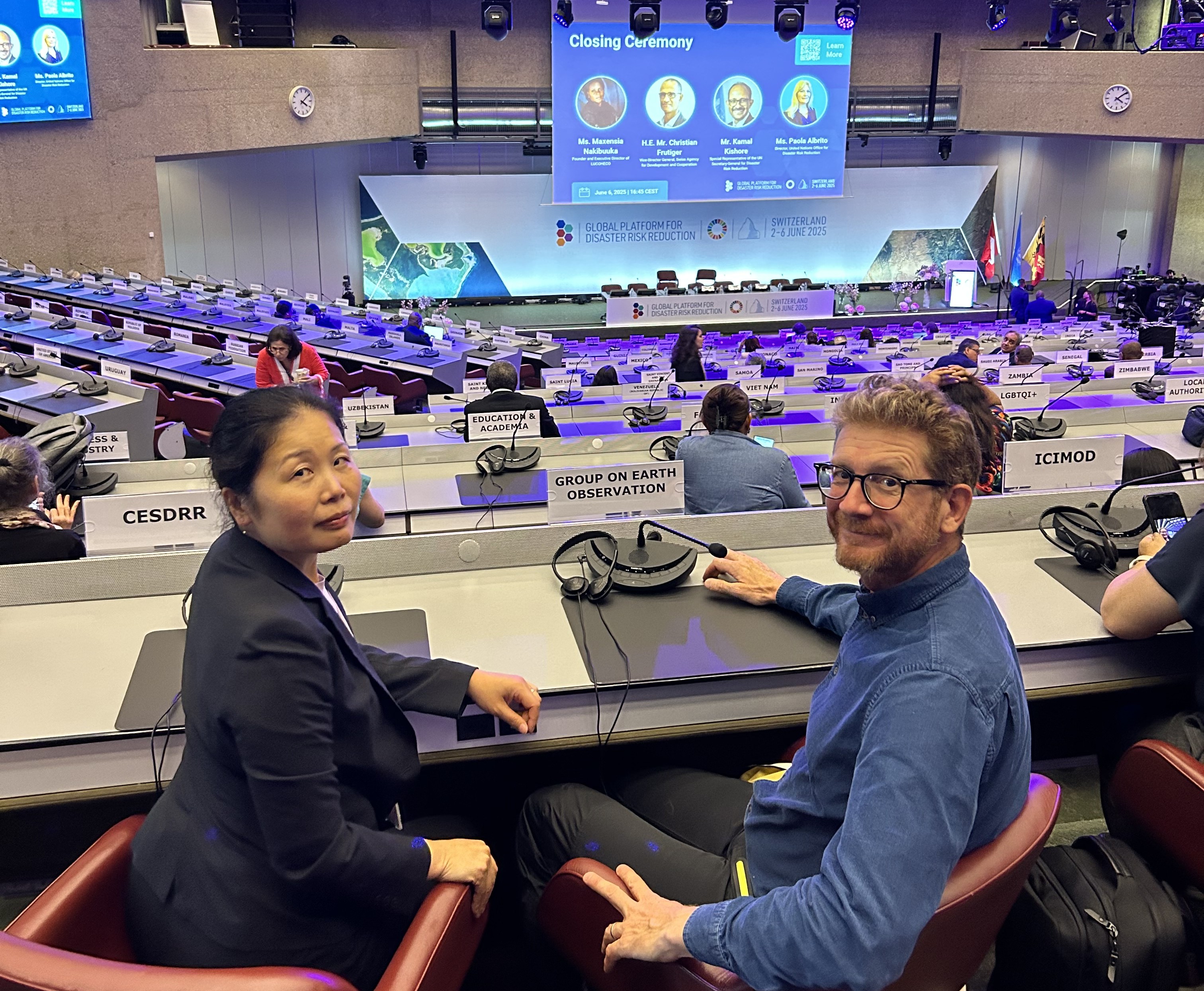
Global Heat Resilience Service</a> turns fragmented data into neighbourhood-scale guidance for mayors and planners: where to cool first, and how."},"tunes":{"textVariant":null,"documentationLink":[]}},{"id":"UNkSOgyfJM","type":"paragraph","data":{"text":"Here's how we bought it to this year's <a href=https://earthobservations.org/"https://globalplatform.undrr.org//">Global Platform for Disaster Risk Reduction (GPDRR)</a>, one of the biggest international conferences on reducing disaster risk, organised by the <a href=https://earthobservations.org/"https://www.undrr.org//">United Nations Office for Disaster Risk Reduction (UNDRR)</a>, one of GEO’s founding <a href=https://earthobservations.org/"https://earthobservations.org/get-involved/participating-org/">Participating Organisations</a>."},"tunes":{"textVariant":null,"documentationLink":[]}},{"id":"R4b6UhPRFl","type":"header","data":{"text":"GEO’s mission validated","level":2},"tunes":{"documentationLink":[]}},{"id":"uCrFZOHNxc","type":"paragraph","data":{"text":"GEO played a key role at GPDRR, shaping two sessions, fielding 12 speakers and running two booths (one on GEO’s disaster risk reduction activities, and another on <a href=https://earthobservations.org/"https://earthobservations.org/groups/digital-earth-pacific/">Digital Earth Pacific</a>, part of the broader <a href=https://earthobservations.org/"https://earthobservations.org/our-work/solutions/">GEO Work Programme</a>). "},"tunes":{"textVariant":null,"documentationLink":[]}},{"id":"I_UIpssRki","type":"paragraph","data":{"text":"In the <a href=https://earthobservations.org/"https://youtu.be/_blSeMrBX44/">Chair’s summary</a>, H.E. Mr. Christian Frutiger underscored two clear messages: we need better data to understand risk. and we must use technology, including artificial intelligence, to accelerate progress."},"tunes":{"textVariant":null,"documentationLink":[]}},{"id":"IxCOb2OUDJ","type":"paragraph","data":{"text":"These key points, echoed throughout the week, strongly validate GEO’s mission: delivering Earth intelligence for All to strengthen resilience and early warnings."},"tunes":{"textVariant":null,"documentationLink":[]}},{"id":"H-a55-V6lI","type":"image","data":{"url":"/storage/news/2025/matyn.jpeg","caption":null,"vertical":false,"stretched":false,"small":false},"tunes":{"documentationLink":[]}},{"id":"LSQgdzgWC8","type":"header","data":{"text":"Advancing GEO’s efforts on extreme heat","level":2},"tunes":{"documentationLink":[]}},{"id":"YgR3gKxP4t","type":"paragraph","data":{"text":"A concrete example of how we’re delivering on our commitments can be seen in the Global Heat Resilience Service. Highlighted at the GEO booth within the <a href=https://earthobservations.org/"https://globalplatform.undrr.org/news/applications-innovation-platform-and-ignite-stage-gp2025-are-now-open#:~:text=The%20GP2025%20Innovation%20Platform%20offers%20a%20dedicated%20space,use%20of%20new%20technology%2C%20awareness-raising%20and%20educational%20activities.\">Innovation Platform</a> and on the <a href=https://earthobservations.org/"https://globalplatform.undrr.org/2025/programme/agenda/ignite-stage/">Ignite Stage</a>, Martyn Clark (GEO Secretariat) shared how GHRS will give city leaders and planners neighbourhood-level heat risk insights to guide zoning, infrastructure upgrades and service delivery."},"tunes":{"textVariant":null,"documentationLink":[]}},{"id":"zuNuB9t24D","type":"paragraph","data":{"text":"He outlined key features of a digital decision-support tool now in development with partners in cities, including São Paulo, Bangalore and Freetown. PreventionWeb later ran a piece titled, “<a href=https://earthobservations.org/"https://www.preventionweb.net/drr-community-voices/smart-tool-beating-urban-heat-actionable-insight/">A smart tool beating urban heat with actionable insights</a>.” Watch Martyn’s presentation below."},"tunes":{"textVariant":null,"documentationLink":[]}},{"id":"uEex8dFdNh","type":"embed","data":{"service":"youtube","source":"https://youtu.be/qcqjWbdRnl8?feature=shared","embed":"https://www.youtube.com/embed/qcqjWbdRnl8?","width":580,"height":320,"caption":null}},{"id":"JjFkYQiaFR","type":"header","data":{"text":"Growing collaboration with UNDRR","level":2},"tunes":{"documentationLink":[]}},{"id":"TcVklBZwko","type":"paragraph","data":{"text":"UNDRR, as <a href=https://earthobservations.org/"https://globalplatform.undrr.org/conference-event/se2-extreme-heat-risk-governance/">a co-lead on global extreme heat risk governance</a>, works with GEO, providing the data and tools to support the governance framework, with case studies from cities and contributions to UNDRR’s flagship reports, such as the UN Global Assessment Report on DRR."},"tunes":{"textVariant":null,"documentationLink":[]}},{"id":"qJbY50hmi1","type":"paragraph","data":{"text":"One significant takeaway from GPDRR 2025 is that GEO’s contributions to disaster risk reduction and early warning are growing, powered by ever-closer collaboration with UNDRR. "},"tunes":{"textVariant":null,"documentationLink":[]}}],"version":"2.29.1"},"created_at":"2025-08-26T11:25:40.000000Z","updated_at":"2025-08-26T17:00:43.000000Z","is_hidden":false,"image_caption":null,"tags":[{"id":2,"name":"Blog","short_name":"Blog","slug":"blog","description":null,"sort_order":1,"created_at":null,"updated_at":"2025-04-04T10:24:48.000000Z","pivot":{"taggable_type":"App\\Models\\Post","taggable_id":139,"tag_id":2}},{"id":3,"name":"Impact","short_name":"Impact","slug":"impact","description":null,"sort_order":1,"created_at":null,"updated_at":"2025-04-04T10:24:48.000000Z","pivot":{"taggable_type":"App\\Models\\Post","taggable_id":139,"tag_id":3}}]},{"id":137,"title":"From open data to empowering global Insights with the Copernicus Data Space Ecosystem","slug":"from-open-data-to-empowering-global-insights-with-the-copernicus-data-space-ecosystem","image":"/storage/news/2025/NDVI_TimeSeries.png","published_at":"2025-07-25 09:39:00","content":{"time":1753436779165,"blocks":[{"id":"m4aZwioQom","type":"paragraph","data":{"text":"Launched in January 2023, the <a href=https://earthobservations.org/"https://dataspace.copernicus.eu/">Copernicus Data Space Ecosystem</a> (CDSE) provides instant, free, and open access to a vast array of Earth observation data. It offers imagery from the Copernicus Sentinel missions, along with high-resolution data from other contributing satellite missions. The platform also includes federated datasets and began with the native integration of data from the Copernicus Land Monitoring Service. By revolutionising how data is accessed and used, the CDSE empowers researchers, policymakers, and industry professionals to leverage Earth observation insights for sustainable development and innovation."},"tunes":{"textVariant":null,"documentationLink":[]}},{"id":"dviU2gwOiY","type":"header","data":{"text":"Unleashing the power of open data","level":2},"tunes":{"documentationLink":[]}},{"id":"t66P4aWNDF","type":"paragraph","data":{"text":"The CDSE is the largest repository of Earth observation data, offering more than 80 petabytes of information, expected to exceed 100 petabytes by 2028. This ecosystem provides seamless access to data from Sentinel satellites and Copernicus services, fostering innovation in environmental monitoring, disaster management and climate action."},"tunes":{"textVariant":null,"documentationLink":[]}},{"id":"LWBjdyr-jh","type":"paragraph","data":{"text":"CDSE is highly operational, with open Key Performance Indicators (KPIs) and real-time monitoring available through a dashboard. This transparency allows users to track data availability, system performance and service usage metrics. The platform's success is evident in its incredible uptake with more than 322,000 users registered and almost 800 PB of sentinel data downloaded."},"tunes":{"textVariant":null,"documentationLink":[]}},{"id":"bdiTnEdIeK","type":"paragraph","data":{"text":"Beyond accessibility, CDSE offers a highly versatile ecosystem, providing data through a user-friendly <a href=https://earthobservations.org/"https://browser.dataspace.copernicus.eu/">browser interface</a> for human interaction, processing capacity via <a href=https://earthobservations.org/"https://dataspace.copernicus.eu/analyse/jupyterlab/">Jupyterlab interfaces and machine-to-machine access via robust APIs such as <a href=https://earthobservations.org/"https://dataspace.copernicus.eu/analyse/openeo/">OpenEO. Implementation of multiple open standards ensures interoperability, making it an essential tool for geospatial analytics. Users can download or process data close to the source, leveraging scalable cloud infrastructure that enhances usability and computational efficiency."},"tunes":{"textVariant":null,"documentationLink":[]}},{"id":"P-Pta19RlA","type":"paragraph","data":{"text":"CDSE is a prime example of the successful implementation of the <a href=https://earthobservations.org/"https://gkhub.earthobservations.org/packages/3p7vv-ykj55/">GEO Data Sharing and Data Management Principles</a>. It adheres to the principles of open access, interoperability, and transparency, ensuring that users worldwide can freely access, share, and process Earth observation data with minimal restrictions. CDSE supports global collaboration and enhances the impact of Earth observation data across multiple domains."},"tunes":{"textVariant":null,"documentationLink":[]}},{"id":"vBuLPh5fE3","type":"paragraph","data":{"text":"The first <a href=https://earthobservations.org/"https://www.copernicus.eu/en/commission-releases-first-copernicus-market-report?\%22>Copernicus Market Report in 2015</a> analysed the impact of Copernicus on eight key sectors, concluding that the cumulative economic value during the period 2008–2020 is significantly above the overall investment in the programme, with a cumulative economic value estimated at €13.5 billion, while total investments are forecast to reach €7.4 billion."},"tunes":{"textVariant":null,"documentationLink":[]}},{"id":"7q8x-Y1ypa","type":"paragraph","data":{"text":"A <a href=https://earthobservations.org/"https://www.copernicus.eu/en/news/news/study-estimates-copernicus-benefits-be-10-times-its-costs?\%22>study in 2018</a> to support the European Commission's Impact Assessment on the evolution of the Copernicus programme estimated that, during the period 2017–2035, Copernicus is expected to generate €67 to €131 billion in benefits to European society, representing a return of 10 to 20 times the cost of the programme."},"tunes":{"textVariant":null,"documentationLink":[]}},{"id":"CVlVQ2IMos","type":"paragraph","data":{"text":"The second Copernicus Market Report in 2019 highlighted that Copernicus had already positively impacted various sectors, including agriculture, forestry, urban monitoring, insurance, ocean monitoring, oil and gas, renewable energies, and air quality management. For instance, in the energy sector, Copernicus ERA5 technology had increased the project return for every 100 megawatts produced through wind energy, from €1 million to €3 million."},"tunes":{"textVariant":null,"documentationLink":[]}},{"id":"iqR6qUIbBj","type":"paragraph","data":{"text":"With its extensive data offerings, seamless integration capabilities, and an ever-expanding user base, the CDSE is a true success story in democratizing Earth observation data access and empowering decision-makers worldwide."},"tunes":{"textVariant":null,"documentationLink":[]}},{"id":"0RzAQrfqEf","type":"paragraph","data":{"text":"The Copernicus Data Space Ecosystem is transforming global access to Earth observation data, enabling users to derive actionable insights for tackling climate change, disaster response, and sustainable development. Its rapid uptake highlights its value in the geospatial community"},"tunes":{"textVariant":null,"documentationLink":[]}}],"version":"2.29.1"},"created_at":"2025-07-25T09:50:34.000000Z","updated_at":"2025-07-25T10:23:52.000000Z","is_hidden":false,"image_caption":null,"tags":[{"id":2,"name":"Blog","short_name":"Blog","slug":"blog","description":null,"sort_order":1,"created_at":null,"updated_at":"2025-04-04T10:24:48.000000Z","pivot":{"taggable_type":"App\\Models\\Post","taggable_id":137,"tag_id":2}},{"id":3,"name":"Impact","short_name":"Impact","slug":"impact","description":null,"sort_order":1,"created_at":null,"updated_at":"2025-04-04T10:24:48.000000Z","pivot":{"taggable_type":"App\\Models\\Post","taggable_id":137,"tag_id":3}}]},{"id":136,"title":"Driving innovation through Landsat's open data policy","slug":"driving-innovation-through-landsat-s-open-data-policy","image":"/storage/news/2025/LDCM_over_Earth_4k.jpg","published_at":"2025-07-24 09:39:00","content":{"time":1753351550096,"blocks":[{"id":"LQbG_Gvi8z","type":"paragraph","data":{"text":"<a href=https://earthobservations.org/"https://landsat.gsfc.nasa.gov//">Landsat, one of the longest-running Earth observation satellite programs, revolutionised data sharing with its bold move to an open-access policy in 2008. This decision drastically increased the availability and utilisation of geospatial data, illustrating the immense value of free and open data for economic, environmental and societal advancements."},"tunes":{"textVariant":null,"documentationLink":[]}},{"id":"r6BZulEoZX","type":"paragraph","data":{"text":"Data sharing is revolutionising the way the world addresses global challenges, from disaster response to climate adaptation. By embracing open access and collaboration, organisations and initiatives worldwide are enabling innovative solutions that save lives, drive economic growth, and foster sustainable development."},"tunes":{"textVariant":null,"documentationLink":[]}},{"id":"xeTCqSkhjI","type":"quote","data":{"text":"“Open data policies, like the Landsat one, have transformed how we approach environmental monitoring and analyses. Studies, like the Australian Data Cube, can now be conducted over very large areas – continental and global scales – resulting in accessible and actionable results.”","caption":"Barbara Ryan, WGIC","alignment":"left"},"tunes":{"documentationLink":[]}},{"id":"obSSoHWljY","type":"header","data":{"text":"Unleashing the power of open data","level":2},"tunes":{"documentationLink":[]}},{"id":"I3gG20bceG","type":"paragraph","data":{"text":"Landsat has been a cornerstone of global Earth observations since its inception in 1972. Its full impact, however, was limited by data costs, with prices reaching $4,500 per scene during the 1980’s when the commercial sector operated the satellite. In 2008, a paradigm shift occurred: the United States Geological Survey (USGS) transitioned to a free (meaning no additional cost to the user) and open data policy marking a turning point in geospatial data accessibility."},"tunes":{"textVariant":null,"documentationLink":[]}},{"id":"7WsNgsSAtv","type":"paragraph","data":{"text":"This decision was based on the recognition that the revenue generated – approximately $5 million annually – was predominantly money being exchanged between public institutions. It was projected that this recirculation was only a fraction of the potential economic and societal benefits attributed to Landsat."},"tunes":{"textVariant":null,"documentationLink":[]}},{"id":"XaAYUBfl1X","type":"paragraph","data":{"text":"The impact was immediate and profound. The daily download rate skyrocketed from 53 scenes to more than 5,700, and subsequent analyses (2011) revealed annual economic benefits of $1.7 billion in the United States alone."},"tunes":{"textVariant":null,"documentationLink":[]}},{"id":"AZ6da7ZWiW","type":"paragraph","data":{"text":"A 2015 <a href=https://earthobservations.org/"https://www.usgs.gov/news/featured-story/landsat-seen-stunning-return-public-investment#:~:text=The%20bottom%20line%20to%20begin&text=The%20economic%20value%20of%20just,in%20any%20conventional%20business%20setting.\">study</a> highlighted that the economic value of just one year of Landsat data far exceeds the multi-year total cost of building, launching, and managing Landsat satellites and sensors. A <a href=https://earthobservations.org/"https://www.usgs.gov/news/featured-story/landsats-economic-value-increases-256-billion-2023/">later study (2024)</a> estimated these benefits to be in the order of $25 billion annually, far exceeding the $5 million collected in data sales by the USGS. This policy shift also enabled transformative technological advancements, such as Australia’s water resource mapping, which analysed 300,000 Landsat scenes to monitor continental-scale water trends."},"tunes":{"textVariant":null,"documentationLink":[]}},{"id":"v4TcNpP5yP","type":"paragraph","data":{"text":"These achievements exemplify how open data drives innovation and supports global policy initiatives like the Paris Agreement and the UN Sustainable Development Goals (SDGs)."},"tunes":{"textVariant":null,"documentationLink":[]}},{"id":"nO5eGZ3NIz","type":"paragraph","data":{"text":"Through its advocacy and role in implementing open data policies, GEO has been instrumental in fostering broader access to Earth observation data, further emphasising the significance of initiatives like Landsat."},"tunes":{"textVariant":null,"documentationLink":[]}},{"id":"oBel4q4uWO","type":"paragraph","data":{"text":"Making Landsat data openly available catalysed a global movement toward open-access Earth observation, unlocking unprecedented economic, scientific, and societal benefits. Data sharing is not just a technological advancement—it’s a global movement enabling collaboration, saving lives, and driving sustainable development."},"tunes":{"textVariant":null,"documentationLink":[]}}],"version":"2.29.1"},"created_at":"2025-07-24T10:09:21.000000Z","updated_at":"2025-07-24T10:09:44.000000Z","is_hidden":false,"image_caption":null,"tags":[{"id":2,"name":"Blog","short_name":"Blog","slug":"blog","description":null,"sort_order":1,"created_at":null,"updated_at":"2025-04-04T10:24:48.000000Z","pivot":{"taggable_type":"App\\Models\\Post","taggable_id":136,"tag_id":2}},{"id":3,"name":"Impact","short_name":"Impact","slug":"impact","description":null,"sort_order":1,"created_at":null,"updated_at":"2025-04-04T10:24:48.000000Z","pivot":{"taggable_type":"App\\Models\\Post","taggable_id":136,"tag_id":3}}]},{"id":120,"title":"How Earth observations transformed land monitoring over 20 years","slug":"how-earth-observations-transformed-land-monitoring-over-20-years","image":"/storage/news/2025/Sentinel-1_up_close.png","published_at":"2025-03-24 16:51:28","content":{"time":1744995380000,"blocks":[{"id":"680284346eb8a","type":"paragraph","data":{"text":"Satellite Earth observations have been around since the 1970s, but turning them into reliable land monitoring services has long been hindered by data gaps, evolving algorithms and shifting policy needs."}},{"id":"680284346eb8c","type":"paragraph","data":{"text":"But all that has changed over the past two decades."}},{"id":"680284346eb8e","type":"paragraph","data":{"text":"Twenty years ago, I was managing national land cover mapping projects in the UK that struggled to get complete image coverage during, or even close to, the reference year they were supposed to represent."}},{"id":"680284346eb8f","type":"paragraph","data":{"text":"There was a lack of Earth observation data at this time, particularly from optical satellite systems that could record detail at field and city block scales over large areas. They only acquired images of each point on the surface every few weeks at best. These acquisition frequencies were reduced further when cloud contamination and natural landscape cycles were considered."}},{"id":"680284346eb90","type":"paragraph","data":{"text":"It took years to compile suitable and comprehensive image coverages for a viable area of interest. For instance, the UK Land Cover Map 2000 took four years to acquire the bare minimum of the required data and still only reached 99% completion."}},{"id":"680284346eb93","type":"paragraph","data":{"text":"<strong>From data scarcity to data deluge</strong>"}},{"id":"680284346eb95","type":"paragraph","data":{"text":"With the Copernicus Sentinel satellites (especially Sentinel-1 and 2), harmonisation with US Landsat and the rise of commercial imaging constellations, we’re now flooded with satellite images. This wealth of data now makes it possible to produce annual land cover maps using rich time series, instead of relying on the limited dual-season snapshots of the past."}},{"id":"680284346eb96","type":"paragraph","data":{"text":"We have swapped the challenge of data scarcity with the challenge of dealing with a data deluge! In many ways this is a positive change, as we can now guarantee sufficient data in our reference periods. But it also raises questions about how we can and should characterise landscapes with these rich time series."}},{"id":"680284346eb97","type":"paragraph","data":{"text":"This highlights the limitations of conventional hard classification approaches, which give a single label for an area, and the opportunities of being able to map multiple landscape characteristics and processes such as vegetation phenology, management practices and episodic events like floods."}},{"id":"680284346eb98","type":"paragraph","data":{"text":"So, the advances over the last 20 years must also be accompanied by paradigm shifts in how we monitor landscapes and the exploitation of the additional value that can be extracted from available data. This is likely to exceed the impact of moving from paper maps to digital geospatial databases."}},{"id":"680284346eb9a","type":"paragraph","data":{"text":"There are exciting times ahead."}},{"id":"680284346eb9b","type":"paragraph","data":{"text":"Image: Sentinel-1/ESA"}},{"id":"680284346eb9c","type":"delimiter","data":[],"tunes":{"documentationLink":[]}},{"id":"680284346eba1","type":"paragraph","data":{"text":"This blog from Geoff Smith of <a href=https://earthobservations.org/"http://www.specto-natura.co.uk//">Specto Natura</a> is part of a series to mark 20 years of the Group on Earth Observations. We are calling on the GEO community to contribute to this series. Choose from one of two themes:"}},{"id":"680284346ebac","type":"list","data":{"style":"unordered","items":[{"content":"<strong>20 years of data</strong>: How the world has changed. How has data helped us understand global change? Share key datasets, insights and visualisations.","items":[]},{"content":"<strong>Then and now</strong>. Thoughts and reflections on how Earth observations and GEO have evolved. Where did we begin, where are we now, what’s next?","items":[]}]},"tunes":{"documentationLink":[]}},{"id":"680284346ebae","type":"paragraph","data":{"text":"Blogs should be no more than 400 words, informal but professional, and avoid excessive jargon. Send your ideas, drafts and questions to mcrook.ext@geosec.org"}}],"version":"2.29.1"},"created_at":"2025-03-24T17:51:42.000000Z","updated_at":"2025-03-24T17:51:42.000000Z","is_hidden":false,"image_caption":null,"tags":[{"id":3,"name":"Impact","short_name":"Impact","slug":"impact","description":null,"sort_order":1,"created_at":null,"updated_at":"2025-04-04T10:24:48.000000Z","pivot":{"taggable_type":"App\\Models\\Post","taggable_id":120,"tag_id":3}}]},{"id":117,"title":"Global Heat Resilience Service continues to build momentum","slug":"global-heat-resilience-service-continues-build-momentum","image":"/storage/news/2025/AdobeStock_271904307.jpeg","published_at":"2025-03-20 19:32:41","content":{"time":1744995380000,"blocks":[{"id":"680284346d3d2","type":"paragraph","data":{"text":"As we move through 2025, the <a href=https://earthobservations.org/"https://earthobservations.org/solutions/incubators/global-heat-resilience-service/">Global Heat Resilience Service</a> (GHRS) is making significant strides in the fight against extreme heat. From securing key partnerships to advancing our decision-support platform, we’re accelerating efforts to help cities worldwide protect their populations from rising temperatures."}},{"id":"680284346d3d4","type":"paragraph","data":{"text":"Here’s what’s new with GHRS:"}},{"id":"680284346d3d5","type":"header","data":{"text":"A major milestone","level":2}},{"id":"680284346d3d8","type":"paragraph","data":{"text":"<strong>GHRS included in the GEO Work Programme</strong>"}},{"id":"680284346d3da","type":"paragraph","data":{"text":"We’re excited to announce that GHRS has been formally accepted into the Post-2025 GEO Work Programme as a Pilot Initiative. This integration places GHRS within three critical focus areas:"}},{"id":"680284346d3df","type":"list","data":{"style":"unordered","items":[{"content":"Climate, energy, and urbanisation – Addressing heat resilience in the context of growing cities.","items":[]},{"content":"One Health – Recognising the direct impact of extreme heat on human health.","items":[]},{"content":"Weather, hazard, and disaster resilience – Aligning with global efforts to strengthen preparedness.","items":[]}]},"tunes":{"documentationLink":[]}},{"id":"680284346d3e0","type":"paragraph","data":{"text":"This milestone solidifies GHRS’s role in international collaboration, ensuring our work aligns with GEO’s strategic priorities."}},{"id":"680284346d3e1","type":"header","data":{"text":"Advancing our three core components","level":2}},{"id":"680284346d3e4","type":"paragraph","data":{"text":"<strong>Component 1: Methodology development</strong>"}},{"id":"680284346d3e5","type":"paragraph","data":{"text":"(March 2025 - June 2027)"}},{"id":"680284346d3e9","type":"paragraph","data":{"text":"We've made substantial progress in developing scientific methodologies for urban-scale heat-risk assessment. Funded by the European Union, the <a href=https://earthobservations.org/"https://earthobservations.org/news/iclimateaction-advancing-earth-intelligence-through-collaboration-and-innovation/">iClimateAction initiative</a> strengthens collaboration between the Global Climate Observing System, World Meteorological Organization and GEO to streamline how climate data is collected, managed and transformed into decision-ready insights."}},{"id":"680284346d3ea","type":"delimiter","data":[],"tunes":{"documentationLink":[]}},{"id":"680284346d3ec","type":"paragraph","data":{"text":"<strong>Component 2: Decision-support platform development</strong>"}},{"id":"680284346d3ed","type":"paragraph","data":{"text":"(March 2025 - March 2027)"}},{"id":"680284346d3f1","type":"paragraph","data":{"text":"GEO has <a href=https://earthobservations.org/"https://earthobservations.org/news/ibm-c40-cities-and-group-earth-observations-collaborate-new-ai-project-resilient-cities/">formalised a partnership</a> with the C40 Cities Climate Leadership Group to collaboratively develop the Global Heat Resilience Service (GHRS). This partnership is accelerating the development of a digital decision-support platform for extreme heat through a recent IBM Sustainability Accelerator Grant awarded to C40. GEO will provide technical expertise to this project, allowing us to test key GHRS concepts."}},{"id":"680284346d3f2","type":"paragraph","data":{"text":"This collaboration is backed by up to $3 million in resources, including direct funding, access to advanced technology, and expert consulting services. The development of the GHRS decision-support platform follows IBM’s proven Garage methodology for digital transformation. The implementation will roll out in two key phases:"}},{"id":"680284346d3f7","type":"list","data":{"style":"unordered","items":[{"content":"<strong>MVP Development</strong> (March 2025 – March 2026): The first phase focuses on designing, creating, and testing a Minimum Viable Product (MVP).","items":[]},{"content":"<strong>Scale-Up Phase</strong> (March 2026 – March 2027): Based on pilot feedback and evaluation, this phase will expand the implementation to ensure broader impact.","items":[]}]},"tunes":{"documentationLink":[]}},{"id":"680284346d3fb","type":"paragraph","data":{"text":"To ensure effectiveness, GHRS will be tested in pilot cities across multiple regions, including Brazil, India, Sierra Leone and Europe. The initiative has also received endorsement from the Global Covenant of Mayors for Climate and Energy, reinforcing its alignment with global urban resilience efforts."}},{"id":"680284346d3fc","type":"delimiter","data":[],"tunes":{"documentationLink":[]}},{"id":"680284346d3fe","type":"paragraph","data":{"text":"<strong>Component 3: Heat governance and policy</strong>"}},{"id":"680284346d3ff","type":"paragraph","data":{"text":"(Building evidence for improved urban heat management.)"}},{"id":"680284346d404","type":"paragraph","data":{"text":"While GHRS is actively seeking dedicated funding for its heat governance and policy component, several key collaborations are already underway. GHRS is contributing to <a href=https://earthobservations.org/"https://www.undrr.org/publication/urban-heat-risk-management-resource-package#:~:text=The%20package%20offers%20clear%2C%20practical,heat%20risk%20assessment%20and%20mapping.\">WMO-UNDRR’s Heat Solutions Package</a>, helping to develop a common framework for UN agencies responding to extreme heat challenges. This ensures that GHRS aligns with broader international governance approaches."}},{"id":"680284346d405","type":"paragraph","data":{"text":"In parallel, the team is exploring alignment with existing city climate action planning frameworks to ensure seamless integration. Efforts are also focused on developing comprehensive business cases to attract potential funding partners. Additionally, GHRS is engaging with city networks to better understand governance needs and inform future policy solutions."}},{"id":"680284346d406","type":"header","data":{"text":"Looking ahead","level":2}},{"id":"680284346d408","type":"paragraph","data":{"text":"The IBM Sustainability Accelerator partnership represents a transformative step forward in creating an AI-powered solution to help cities analyze heat risks and develop effective<br>adaptation strategies. As temperatures rise and cities grow, this solution will become increasingly essential for protecting vulnerable populations and urban economies."}},{"id":"680284346d409","type":"paragraph","data":{"text":"In the coming months, our focus will be on:"}},{"id":"680284346d40f","type":"list","data":{"style":"ordered","items":[{"content":"Launching the implementation of Components 1 and 2","items":[]},{"content":"Securing additional partnerships for Component 3","items":[]},{"content":"Expanding our network of pilot cities","items":[]},{"content":"Developing communication materials to raise awareness of heat risks","items":[]}]},"tunes":{"documentationLink":[]}},{"id":"680284346d410","type":"paragraph","data":{"text":"GHRS will continue its mission to provide actionable intelligence that helps cities address the estimated 500,000 excess deaths per year caused by extreme heat, with particular focus on vulnerable urban communities."}},{"id":"680284346d415","type":"paragraph","data":{"text":"Catch us next at the <a href=https://earthobservations.org/"https://earthobservations.org/events/geo-global-forum-2025/">GEO Global Forum</a> in Rome in May and then the <a href=https://earthobservations.org/"https://globalplatform.undrr.org//">UNDRR Global Platform</a> in Geneva in June. Additional outreach opportunities being explored at New York Climate Week and the C40 Mayor's Summit in Rio."}},{"id":"680284346d416","type":"paragraph","data":{"text":"For more information or to explore partnership opportunities, please contact Martyn Clark at mclark@geosec.org."}}],"version":"2.29.1"},"created_at":"2025-03-20T20:34:14.000000Z","updated_at":"2025-03-21T09:36:09.000000Z","is_hidden":false,"image_caption":null,"tags":[{"id":3,"name":"Impact","short_name":"Impact","slug":"impact","description":null,"sort_order":1,"created_at":null,"updated_at":"2025-04-04T10:24:48.000000Z","pivot":{"taggable_type":"App\\Models\\Post","taggable_id":117,"tag_id":3}}]},{"id":116,"title":"How Earth Intelligence can help improve air quality and respiratory health","slug":"how-earth-intelligence-can-help-improve-air-quality-and-respiratory-health","image":"/storage/news/2025/AdobeStock_130645635.jpeg","published_at":"2025-03-17 22:25:35","content":{"time":1744995380000,"blocks":[{"id":"680284346ca7c","type":"paragraph","data":{"text":"Air pollution is one of the biggest threats to public health, contributing to millions of deaths each year. But traditional air quality monitoring currently leaves gaps in our understanding and response. This is where Earth Intelligence – the use of satellite observations, remote sensing and environmental data – can help."}},{"id":"680284346ca84","type":"paragraph","data":{"text":"The <a href=https://earthobservations.org/"https://www.geohealthcop.org//">GEO Health Community of Practice</a>’s <a href=https://earthobservations.org/"https://www.geohealthcop.org/workgroup/airquality/">Air Quality, Wildfires, and Respiratory Health Work Group</a> leverages Earth Intelligence to bridge these gaps, offering new ways to monitor pollution, predict risks and protect both human and environmental health."}},{"id":"680284346ca85","type":"paragraph","data":{"text":"In this post, we highlight five key ways the group is using Earth Intelligence to help improve air quality and respiratory health."}},{"id":"680284346ca86","type":"header","data":{"text":"The One Health approach","level":2}},{"id":"680284346ca8b","type":"paragraph","data":{"text":"Air quality issues intersect human, animal and environmental health, making the One Health collaborative, multidisciplinary approach essential. Poor air quality <a href=https://earthobservations.org/"https://www.stateofglobalair.org/resources/report/state-global-air-report-2024/">contributes to one in nine deaths globally</a>, and poor environmental health can exacerbate wildfires and dust storms."}},{"id":"680284346ca8c","type":"paragraph","data":{"text":"By advancing best practices for harnessing Earth Intelligence to monitor and manage pollutants, the Work Group supports health risk prediction and capacity building among stakeholders."}},{"id":"680284346ca8d","type":"header","data":{"text":"Using satellite data to fill gaps in understanding","level":2}},{"id":"680284346ca91","type":"paragraph","data":{"text":"<a href=https://earthobservations.org/"https://openaq.medium.com/73-of-national-governments-fail-to-provide-fully-transparent-air-pollution-data-d22ca76e62ca/">Ground-based air quality monitoring networks are sparse globally</a>, limiting our understanding of air pollution. Satellite Earth observation data can fill these gaps by providing regional and global air quality patterns and trends."}},{"id":"680284346ca92","type":"paragraph","data":{"text":"These data are also crucial for issuing early warnings about air pollution events including dust storms and wildfires, allowing vulnerable populations to take precautions. Finally, combining satellite Earth observation data with health data helps researchers understand the public health impacts of air pollution and informs effective regulations. The Work Group identifies, collects, and disseminates examples of best practices and new advances in using satellite Earth observations to fill ground-based air quality data gaps."}},{"id":"680284346ca93","type":"header","data":{"text":"Making data accessible","level":2}},{"id":"680284346ca97","type":"paragraph","data":{"text":"Despite the benefits, challenges including data access, interpretation, and validation as well as capacity can limit use of Earth observation data for air quality management. Efforts like the <a href=https://earthobservations.org/"https://appliedsciences.nasa.gov/what-we-do/capacity-building/arset/">NASA Applied Remote Sensing Training Program</a> address these gaps by providing free online lessons."}},{"id":"680284346ca9a","type":"paragraph","data":{"text":"The Work Group promotes an inclusive international community of practice to build trust and lower barriers while disseminating the latest capabilities and surveying future opportunities and needs. This includes contributing to tools like the HAQAST <a href=https://earthobservations.org/"https://haqast.org/data-and-tools//">resources flowchart</a>."}},{"id":"680284346ca9b","type":"header","data":{"text":"Promoting solutions","level":2}},{"id":"680284346ca9c","type":"paragraph","data":{"text":"The Work Group promotes successful Earth observation data applications, highlighting innovative uses of Earth observations at the intersection of One Health and air quality."}},{"id":"680284346caa0","type":"paragraph","data":{"text":"The group also develops region-specific resource guides and training workshops, such as the <a href=https://earthobservations.org/"http://www.geohealthcop.org/workshops/2024/8/28/amerigeo2024/">Satellite-Derived Air Quality Information workshop</a> for the Americas. These initiatives build local capacity and inspire collaboration between data providers and users."}},{"id":"680284346caa1","type":"header","data":{"text":"Building a future together","level":2}},{"id":"680284346caa2","type":"paragraph","data":{"text":"The Work Group serves as a forum for international engagement, supporting holistic assessments of air quality and One Health. A key initiative is a survey of global data gaps and recommendations for new Earth observation missions and data products."}},{"id":"680284346caa9","type":"paragraph","data":{"text":"To learn more about the innovative work being done by the GEO Health Community of Practice’s Air Quality, Wildfires, and Respiratory Health Work Group, be sure to read the <a href=https://earthobservations.org/"https://static1.squarespace.com/static/57d4a81b20099e97b489a499/t/67cb7c84942b9c333008e770/1741388932267/CoP_WhitePaper_AirQuality_Mar2025+FINAL.pdf/">full white paper</a>. To get involved, <a href=https://earthobservations.org/"https://www.geohealthcop.org/join-community/">reach out here</a>."}}],"version":"2.29.1"},"created_at":"2025-03-17T23:34:28.000000Z","updated_at":"2025-03-17T23:34:28.000000Z","is_hidden":false,"image_caption":null,"tags":[{"id":3,"name":"Impact","short_name":"Impact","slug":"impact","description":null,"sort_order":1,"created_at":null,"updated_at":"2025-04-04T10:24:48.000000Z","pivot":{"taggable_type":"App\\Models\\Post","taggable_id":116,"tag_id":3}}]},{"id":110,"title":"IBM, C40 Cities and Group on Earth Observations collaborate on new AI project for resilient cities","slug":"ibm-c40-cities-and-group-earth-observations-collaborate-new-ai-project-resilient-cities","image":"/storage/news/2025/SUSTAINABLE _Accelerator_HEADER_1600x9002.png","published_at":"2025-02-11 14:33:47","content":{"time":1744995380000,"blocks":[{"id":"6802843469e91","type":"paragraph","data":{"text":"IBM (NYSE: IBM), <a href=https://earthobservations.org/"https://www.c40.org//">C40 Cities</a> and the Group on Earth Observations today announced a new collaboration through the <a href=https://earthobservations.org/"https://www.ibm.com/impact/initiatives/ibm-sustainability-accelerator/">IBM Sustainability Accelerator</a> aimed at scaling up social innovation action in cities around the world. In alignment with United Nations Sustainable Development Goal (SDG) 11, the new project will develop artificial intelligence (AI) solutions to advance city resiliency and address specific challenges facing urban communities."}},{"id":"6802843469e93","type":"paragraph","data":{"text":"At the beginning of 2024, IBM held a request for proposals (RFP) for nonprofit and government organizations, focused on technology-driven projects to advance city resiliency. Out of more than 100 applicants, C40 Cities was one of five organizations selected to participate in this new cohort of IBM Sustainability Accelerator projects."}},{"id":"6802843469e94","type":"paragraph","data":{"text":"Participants were selected for their significant level of support to the communities they serve, as well as the innovative ways each organization plans to leverage AI technology to build more resilient cities. Each organization will receive up to $3 million in cash and in-kind donations of technology and services."}},{"id":"6802843469e97","type":"paragraph","data":{"text":"With support from the Group on Earth Observations , IBM and C40 Cities, a global network of nearly 100 mayors of the world’s leading cities, will work together to create a data-driven, AI-powered solution to help cities analyze potential risks that may arise as a result of extreme heat and the urban heat island effect. These can include stressed energy resources, increases in mortality rates, and socioeconomic disparities. The new solution will aim to enable cities to create adaptation strategies to help alleviate population health risks and economic burdens, while strengthening national resilience efforts. <a href=https://earthobservations.org/"https://www.globalcovenantofmayors.org//">The Global Covenant of Mayors for Climate and Energy</a> will also support this project."}},{"id":"6802843469e9b","type":"paragraph","data":{"text":"“As cities grow and temperatures continue to rise around the world, so do the challenges of extreme heat and its impact on urban populations. At the Group on Earth Observations, we are committed to turning Earth Intelligence into action by equipping communities with the data they need to build resilience. Through our collaboration with C40 and IBM as part of the IBM Sustainability Accelerator, we will test initial ideas from GEO’s <a href=https://earthobservations.org/"https://earthobservations.org/solutions/incubators/global-heat-resilience-service/">Global Heat Resilience Service</a> to demonstrate how AI-powered insights and geospatial data can help cities mitigate heat risks and protect vulnerable communities. This is a critical step towards creating cooler, safer and more liveable cities for all,” said Yana Gevorgyan, Group on Earth Observations Secretariat Director."}},{"id":"6802843469e9c","type":"paragraph","data":{"text":"The IBM Sustainability Accelerator is a social innovation program that applies IBM technologies, such as hybrid cloud and AI, and an ecosystem of experts to enhance and scale nonprofit and government organization initiatives, accelerating economic impact for communities vulnerable to climate stress ."}},{"id":"6802843469e9d","type":"paragraph","data":{"text":"“AI has the potential to unlock a new economic and innovation era for communities worldwide, helping people tackle the challenges of today and tomorrow. We believe that much of this potential to improve people’s lives resides in transforming cities, and this is what we are aiming to do with our AI technology and expertise,” said Justina Nixon-Saintil, IBM Vice President and Chief Impact Officer."}},{"id":"6802843469e9e","type":"paragraph","data":{"text":"IBM, C40 Cities and the Group on Earth Observations will collaborate over two years and in two phases. The first phase will begin with the IBM Garage, IBM’s proven methodology for accelerating digital transformation and delivering meaningful, measurable, outcomes. Next, during the Development and Implementation phase, IBM experts will configure IBM resources and technology to help participants meet their goals, as well as support pilot deployments in communities and facilitate further scaling."}},{"id":"6802843469e9f","type":"paragraph","data":{"text":"As part of this IBM Sustainability Accelerator cohort, EY teams will provide general capacity building workshops and coaching to the resilient city cohort, supporting these innovative organizations on their mission to make cities more sustainable, equitable, and resilient."}},{"id":"6802843469ea0","type":"paragraph","data":{"text":"To date, 20 organizations have been part of the IBM Sustainability Accelerator supporting vulnerable populations around the world. As of last year, IBM has supported approximately 65,300 direct beneficiaries through our sustainable agriculture cohort, with approximately 1.1 million more projected to benefit from our clean energy cohort. And, we expect these resilient cities projects will benefit thousands of citizens across the world."}},{"id":"6802843469ea2","type":"paragraph","data":{"text":"<strong>About the IBM Sustainability Accelerator</strong>"}},{"id":"6802843469ea6","type":"paragraph","data":{"text":"Launched in 2022, the <a href=https://earthobservations.org/"https://www.ibm.com/impact/initiatives/ibm-sustainability-accelerator/">IBM Sustainability Accelerator</a> is a social innovation program that supports communities facing environmental and economic stress around the world, through technologies like AI and an ecosystem of experts. Each year, the program selects five new projects to develop and scale technology and AI solutions addressing topics like sustainable agriculture, clean energy, water management, resilient cities or sustainable consumption and production."}},{"id":"6802843469ea7","type":"paragraph","data":{"text":"For more information and media enquiries, contact: mcrook.ext@geosec.org"}}],"version":"2.29.1"},"created_at":"2025-02-11T15:39:18.000000Z","updated_at":"2025-02-12T19:50:10.000000Z","is_hidden":false,"image_caption":null,"tags":[{"id":3,"name":"Impact","short_name":"Impact","slug":"impact","description":null,"sort_order":1,"created_at":null,"updated_at":"2025-04-04T10:24:48.000000Z","pivot":{"taggable_type":"App\\Models\\Post","taggable_id":110,"tag_id":3}}]},{"id":109,"title":"Using Earth Intelligence to boost vaccination efforts in Zambia","slug":"using-earth-intelligence-boost-vaccination-efforts-zambia","image":"/storage/news/2025/Akros Zambia blog.jpg","published_at":"2025-02-05 18:00:50","content":{"time":1744995380000,"blocks":[{"id":"680284346993c","type":"paragraph","data":{"text":"Vaccination campaigns save lives, but reaching every child – especially in remote and underserved communities – remains a logistical challenge. In Zambia, health workers rely on hand-drawn maps to plan immunization efforts, making it easy for <a href=https://earthobservations.org/"https://akros.shorthandstories.com/using-geospatial-data-to-reach-missed-communities-and-zero-dose-children-with-life-saving-vaccines/index.html/">entire communities</a> to be missed. Now, Earth Intelligence is transforming vaccine planning by providing precise, up-to-date geographic data to ensure every child receives life-saving immunizations."}},{"id":"6802843469944","type":"paragraph","data":{"text":"Zambia has made <a href=https://earthobservations.org/"https://www.exemplars.health/topics/vaccine-delivery/zambia/why-is-zambia-an-exemplar/">significant progress</a> in protecting its citizens from vaccine-preventable diseases in the past decade, using government investment, community engagement and international partnerships to increase vaccine coverage from <a href=https://earthobservations.org/"https://www.gavi.org/sites/default/files/evaluations/Decentralised/Policy-Brief_Challenge-of-protecting-immunization-financing-under-fiscal-austerity_2020.pdf/">64% in 2013 to 90% in 2018</a>, with the aim to reach 95% vaccination coverage in the next five years."}},{"id":"6802843469949","type":"paragraph","data":{"text":"But barriers in equity and wealth still prevent immunizations for rural, migratory and indigenous settlements. An estimated <a href=https://earthobservations.org/"https://www.unicef.org/zambia/press-releases/unicef-highlights-decline-vaccination-coverage-leaves-children-unprotected-against/">324,619 children in Zambia were zero-dose in 2022, meaning they never received routine vaccinations."}},{"id":"680284346994a","type":"paragraph","data":{"text":"There is an urgent need to vaccinate zero-dose children born during COVID-19, who are now surpassing the normal age of vaccination, to prevent disease outbreaks."}},{"id":"680284346994d","type":"paragraph","data":{"text":"From the GEO community, Zambia’s Expanded Programme on Immunizations (EPI) is deploying Earth observation resources to support vaccine planning at health facilities nationwide through technical assistance from <a href=https://earthobservations.org/"https://www.akros.com//">Akros under a GAVI innovation top up grant and in partnership with the Centre for Infectious Disease Research in Zambia (CIDRZ)."}},{"id":"680284346994e","type":"header","data":{"text":"Mapping local vaccine campaigns","level":2}},{"id":"6802843469952","type":"paragraph","data":{"text":"Zambia uses a bottom-up approach for vaccine planning: local <a href=https://earthobservations.org/"https://www.exemplars.health/topics/vaccine-delivery/zambia/how-did-zambia-implement/">health facilities work with community leaders</a> and representatives to draft microplans, which are then incorporated into district and provincial vaccine planning."}},{"id":"6802843469953","type":"paragraph","data":{"text":"To create and implement these plans, local facilities rely on hand-drawn maps to determine the time and resources needed for vaccinations and identify specific populations that will be difficult to reach."}},{"id":"6802843469954","type":"paragraph","data":{"text":"These maps, while helpful, miss critical details, which can prevent entire communities from receiving life-saving vaccines."}},{"id":"6802843469955","type":"header","data":{"text":"The power of Earth Intelligence","level":2}},{"id":"6802843469957","type":"paragraph","data":{"text":"Akros is creating digital and large-scale paper maps for district and local health facilities, who can use them to demonstrate population distribution, track travel routes and create vaccine microplans tailored to specific zones in their community."}},{"id":"6802843469958","type":"paragraph","data":{"text":"This strategy will provide critical information on vaccine progress to EPI in real time, eliminating delays caused by paper-based mapping and microplanning."}},{"id":"680284346995b","type":"paragraph","data":{"text":"Akros is also partnering with <a href=https://earthobservations.org/"https://www.worldpop.org//">WorldPop to create an updated settlement layer in GIS, which will be used to locate and develop vaccination plans for Zambia’s zero-dose children."}},{"id":"680284346995c","type":"paragraph","data":{"text":"In December 2024, Zambia’s EPI began distributing the maps to all 2,790 health facilities in the country. Digital microplanning tools are now being rolled out in 23 districts, and a digital dashboard and map are accessible online for staff to use in their planning. The project will also serve as a resource for other national health programmes by providing access to GIS data on zero-dose children in Zambia."}},{"id":"680284346995d","type":"paragraph","data":{"text":"With these tools, Zambia’s health facilities will be able to clearly define the geographical extent and population distribution of the area they need to vaccinate. This helps minimise duplicated efforts and ensures no residents are missed, helping reduce preventable disease and infant death in the country’s most vulnerable communities."}},{"id":"6802843469961","type":"paragraph","data":{"text":"By Bwalya Mukuka, Derek Pollard and Anna Winters. A version of this blog originally appeared on the <a href=https://earthobservations.org/"https://akros.shorthandstories.com/using-geospatial-data-to-reach-missed-communities-and-zero-dose-children-with-life-saving-vaccines/index.html/">Akros website</a>."}}],"version":"2.29.1"},"created_at":"2025-02-05T19:04:17.000000Z","updated_at":"2025-02-05T21:11:17.000000Z","is_hidden":false,"image_caption":null,"tags":[{"id":3,"name":"Impact","short_name":"Impact","slug":"impact","description":null,"sort_order":1,"created_at":null,"updated_at":"2025-04-04T10:24:48.000000Z","pivot":{"taggable_type":"App\\Models\\Post","taggable_id":109,"tag_id":3}}]}],"first_page_url":"https://earthobservations.org/index.php/about-us/news?tag=Impact&page=1","from":1,"last_page":2,"last_page_url":"https://earthobservations.org/index.php/about-us/news?tag=Impact&page=2","links":[{"url":null,"label":"« Previous","active":false},{"url":"https://earthobservations.org/index.php/about-us/news?tag=Impact&page=1","label":"1","active":true},{"url":"https://earthobservations.org/index.php/about-us/news?tag=Impact&page=2","label":"2","active":false},{"url":"https://earthobservations.org/index.php/about-us/news?tag=Impact&page=2","label":"Next »","active":false}],"next_page_url":"https://earthobservations.org/index.php/about-us/news?tag=Impact&page=2","path":"https://earthobservations.org/index.php/about-us/news","per_page":8,"prev_page_url":null,"to":8,"total":15},"filters":{"years":["2025","2024","2023","2022","2021","2020","2019"],"tags":[{"id":3,"name":"Impact","pivot":{"taggable_type":"App\\Models\\Post","taggable_id":4,"tag_id":3}},{"id":4,"name":"Youth","pivot":{"taggable_type":"App\\Models\\Post","taggable_id":17,"tag_id":4}},{"id":2,"name":"Blog","pivot":{"taggable_type":"App\\Models\\Post","taggable_id":130,"tag_id":2}},{"id":1,"name":"News","pivot":{"taggable_type":"App\\Models\\Post","taggable_id":132,"tag_id":1}}]},"checked":{"year":null,"tag":"Impact"}},"url":"/index.php/about-us/news?page=1&tag=Impact","version":"d29a61d83d8f3885d71ed43c36a5789b","encryptHistory":false,"clearHistory":false}">